On your next walk in a forest, park, or community, you might notice some interesting trees and plants, perhaps even a few birds or squirrels scurrying around, but chances are you won’t think much about the vast amounts of water below your feet. This water, known as groundwater, resides between the cracks and crevices of the sediment and rock and is a major source of freshwater. It’s critical to the survival of many of the species you see (and many you don’t), and therefore also crucial to the health of certain ecosystems. But how does groundwater affect ecosystems? And how do we go about identifying and finding ecosystems that are dependent on groundwater?
Finding Groundwater Dependent Ecosystems
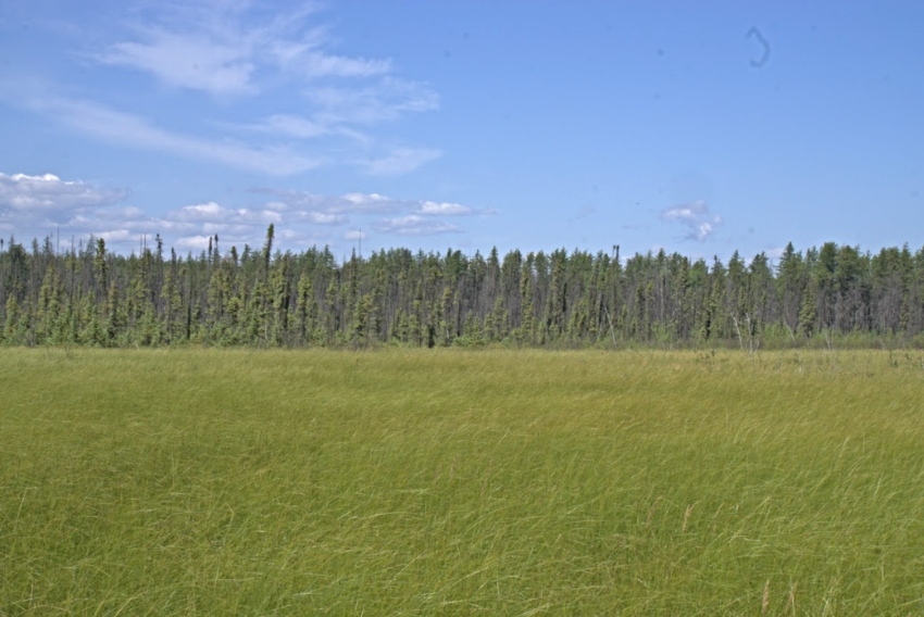
Groundwater dependent ecosystems (GDEs) are ecosystems that are maintained by direct or indirect access to groundwater, and rely on the flow or chemical characteristics of groundwater for some or all of their water requirements. They cover vast areas and come in three major types: aquatic, terrestrial, and subterranean. Aquatic GDEs could be wetlands, lakes, rivers, streams, and springs. Terrestrial GDEs include certain upland forests or riparian areas. And subterranean GDEs cover underground aquifers, karst, and caves.
GDEs are major contributors to biodiversity intactness in a region, supporting a wide range of vegetation and wildlife. GDEs provide important wildlife features like watering holes for mammals, salt licks, and key habitats for waterbird nesting and stopovers. They act as a refuge for aquatic life providing in-stream flow needs and also provide base flow for navigation. Aquatic GDEs provide temperature regulation, and crucial water resources for fish habitat. Underground GDEs host unique microbial communities. The flora and fauna that rely on GDEs also represent an essential harvesting resource for Indigenous communities.
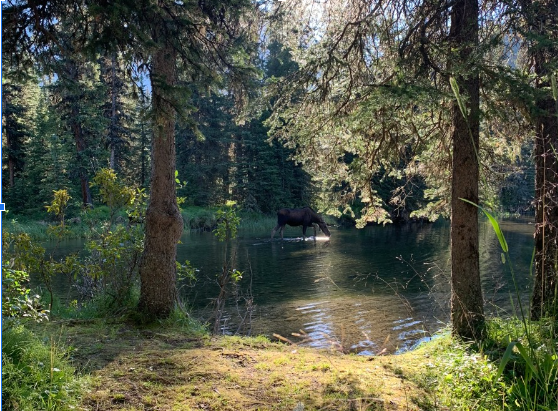
GDEs may be important watering holes for mammals. Photo: Jenet Dooley
GDEs are highly complex systems and come in all different shapes and sizes, making it challenging to accurately identify and map where they exist on the landscape. Globally, the mapping of GDEs has been identified as increasingly urgent to ensure ecosystem and human health protection. Strain on water resources may drive an increased need for national or multinational approaches to GDE mapping. One recent study found that ~75 percent of the global land surface has an interaction with groundwater resources when high mountain and desert terrain are excluded. Another study noted that regions with higher human footprint reflect higher GDE impact risk, showing the need to map GDEs in less disturbed areas to ensure that impacts from groundwater withdrawals and development can be appropriately tracked. Most GDE/biodiversity research papers focus on arid areas, with surprisingly little environmental research on groundwater and biodiversity relationships in the significant GDEs found in boreal ecosystems, including forests in Alberta and the rest of Canada, until now.
Mapping GDEs: Closing Knowledge Gaps
Last year, a group of scientists from the ABMI and InnoTech Alberta began tackling these questions with a unique multi-year project. They aim to map the locations of GDEs in the boreal forests of Alberta, Canada. Through the use of data from multiple sources and innovative mapping techniques (a machine-learning geospatial approach), the project will fill a critical knowledge gap by creating a map product that can be used to identify the best areas to monitor biological systems impacted by changes to groundwater (e.g., quality, levels) due to energy sector activities.
Cynthia McClain, Director of the ABMI’s Geospatial Centre and former co-lead of the Oil Sands Monitoring Groundwater Technical Advisory Committee, has been involved with this GDE mapping project since the beginning, “Identifying GDEs remains a key knowledge gap. Mapping the locations of GDEs is a foundational step in refining monitoring programs to detect and attribute changes in ecosystems that are supported by groundwater such as riparian areas and fens which are the most common type of wetland in this region”.
Thanks to combined experience in remote sensing, mapping, and the wealth of data collection taking place in the region, InnoTech Alberta and the ABMI are well-positioned to support long-term planning that supports groundwater and terrestrial biological monitoring. The team met their first-year objective by developing the first aquatic GDE map for an initial study area.
This proof of concept demonstrates that expanding GDE mapping throughout Alberta’s boreal forest is possible, while recognizing that successful expansion requires that some data gaps are addressed and that a broader set of test data is available. This work will add further value to groundwater, wetland, surface water, and terrestrial monitoring by increasing our understanding of biological indicators and defining a solid and innovative approach to GDE mapping.
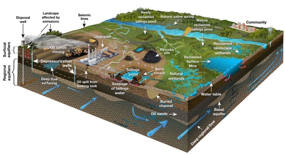
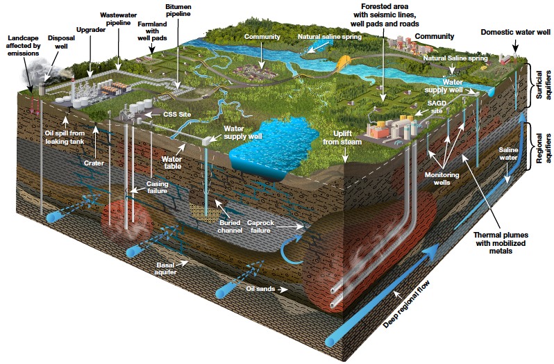
Figure: Groundwater conceptual models for energy sector activities in northeastern Alberta: (a) in-situ, (b) surface mining. Source: Groundwater Vulnerability in the Athabasca and Cold Lake Oil Sands Regions: Gaps, Opportunities and Challenges, Birks et al. (in press) Environmental Reviews
Groundwater Dependent Ecosystems in Northeastern Alberta
GDEs are the main groundwater receptor in the region (there are only a few domestic groundwater wells). They can be sensitive to changes in the quantity and quality of groundwater discharge and, in this case, be influenced by stressors such as groundwater withdrawals, landscape disturbance, tailings pond seepage, etc.
Alberta’s northeast is not only rich in natural resources and biodiversity, but has deep cultural significance and is home to approximately 55 Indigenous communities (29 First Nations, 16 Métis Organizations and 18
Métis Locals). As natural resource development in the region continues to expand, it is important to monitor its effect on local ecosystems and local communities, including nearby Indigenous populations who rely on the environment. Understanding the impacts of various human-led stressors on the region’s landscapes, water resources, and biota is vital to effective land use planning and management.
Answering Key Ecological Questions
As the project team identifies and maps GDE locations, they will be well-positioned to support land managers and resource planners to answer key questions. For example, in the coming year, the team will review literature identifying boreal-occurring terrestrial ecosystems and species that are fully or partially dependent on groundwater. This information would, for example, allow Indigenous communities to cross-reference this list of biological indicators of GDEs with species of importance. For Indigenous communities who rely on local harvesting practices, understanding GDE locations and groundwater changes may allow them to confirm whether changes they have observed in harvested species could be related to groundwater impacts from nearby industrial activities.
Our Approach to Mapping GDEs
The approach to mapping GDEs began with identifying groundwater and biological indicators and the best methods for GDE mapping and map validation through an intensive literature review of GDE indicators and the available groundwater knowledgebase.
“Much of the research on mapping GDEs is focused in arid regions where GDEs can be detected based on their greenness using vegetation indicators and satellite imagery. In wetter environments, such as the boreal region in Canada, there is less research, and visually-based vegetation indicators are not as useful because vegetation is not limited to GDEs. Here we can apply novel methods (isotopic analysis, and thermal imaging) similar to northern European countries to quantify groundwater sources in peatlands and map GDEs.”
Michael Wendlandt, Researcher, Innotech Alberta
The next step was to evaluate data availability for mapping GDEs: selecting, collating and identifying data gaps. Key data sources were compiled and included collaborations with the Alberta Geological Survey, Aquanty’s HGS Athabasca River Basin Model, Government of Canada and the ABMI’s Wetland Inventory for the Oil Sands Monitoring Program.
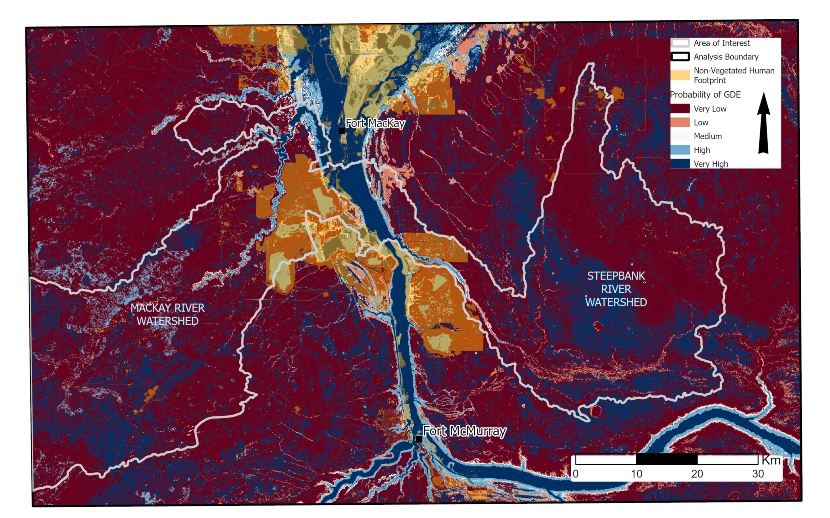
The Mackay River and Steepbank River watersheds were chosen as the pilot study area for preliminary mapping. These areas lend themselves particularly well to the study of GDEs due to their contrasting groundwater contributions (notably higher on the east side of the Athabasca River). In the McKay and Steepbank Rivers, groundwater contribution to streamflow varies seasonally, with higher contributions in the winter, ranging throughout the year from 4-65% and 29-69%, respectively.
By capitalizing on the benefits of machine learning for mapping aquatic GDEs, the project team was able to capitalize on a larger number of diverse data sources for input variables including combining remote sensing and spatially explicit data (geomorphology, biogeography, and hydrology indices) to increase accuracy of identification and mapping of GDEs. Through model refinement, the project team was able to distill the explanatory variables into key variables used for identifying GDEs (wetland class, Advanced Land Observing Satellite (ALOS) digital elevation models, and derivatives, and the permeability of the surficial geology) creating an ensemble map (ENS) of aquatic GDEs probability in the pilot study areas based on the highest preforming machine learning models.
Though data gaps presented some challenges, the team succeeded in mapping aquatic GDEs in the study area.
The final mapping product leverages several data sources, allows for validation of results and extrapolation of a predictive map. Perhaps most excitingly, the mapping product leaves opportunities for scaling up and updating as new data become available (e.g. updated wetlands and depth to water mapping).
This ensemble map provides new information about aquatic GDEs (it likely doesn’t capture some terrestrial GDEs) in the region. We can see that aquatic GDEs occur near human footprint, with ~⅓ of the study area having medium-high probability of GDEs and ~⅔ medium-low probability of GDEs. The map picks up fens, rivers, and streams. Notably, the map shows very high probability GDEs where the lower McKay River is known to have greater gains from groundwater and riparian areas. The summary of a previous study showed fluctuating gauging results, it reported direct contributions of groundwater along various reaches of the MacKay River, and, as a whole, that groundwater might contribute as much as 35% during under ice flow compared to 2-10% during low flows.
The map is inconclusive in terms of lakes due to sparse data, however, incorporating more lake data will be a focus for work in the coming year.
Scaling Up
The focus for future years of the project includes developing methods for mapping other GDE categories (e.g., terrestrial, subterranean) and scaling-up the application of these approaches to cover a broader geographical area.
Supporting long-term planning for groundwater monitoring remains the key focus for scientists working on the GDE mapping project. And by creating a solid framework for mapping GDEs in northern Alberta’s boreal forest, this research is likely to improve understanding of the impacts of energy sector activities on groundwater receptors and have wider ramifications on monitoring GDEs both locally and further afield for a long time to come.
For more information, please contact Cynthia McClain, Geospatial Centre Director, ABMI,
This work was funded by, but does not necessarily reflect the position of, the Oil Sands Monitoring Program.
Footnotes:
- Rohde et al., 2017
- Ruff et al. (2023)
- Saccò et al. (2024)
- Link et al. (2023)
- S.J. Birks, J.J. Gibson, J.W. Fennell, C.N. McClain, D Sayanda, G Bickerton, Y Yi, F. Castrillon-Munoz
- Indigenous fund for community based monitoring
- Martínez -Santos et al. (2021)