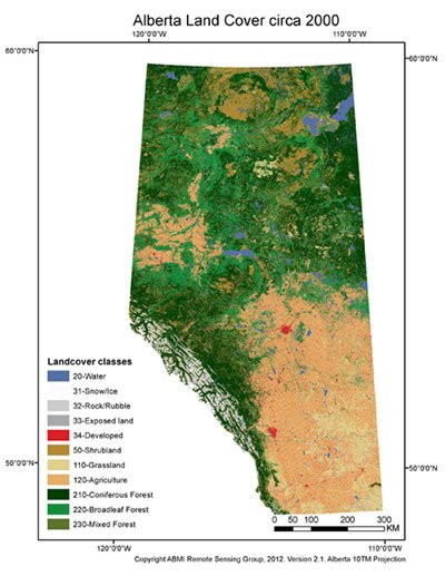
After months of hard work, the ABMI Remote Sensing Group is very pleased to announce the completion and release of the ABMI Wall-to-wall Land Cover Map version 2.1! A long-awaited data product, the spatially exhaustive polygon vector layer represents land cover across Alberta circa 2000, uses 11 land cover classes, and contains roughly one million, non-overlapping polygons. Minimum polygon size is 0.5 ha for aquatic features and 2 ha for all other land covers.
The product was derived from the blending and generalization of two existing raster land cover classifications: the Canadian Forest Service Earth Observation for Sustainable Development Land Cover dataset, and the Agriculture and Agri-Food Canada Land Cover dataset. Both are Landsat-based classifications, have a 30 m spatial resolution, and contain the same land cover classes. Hydrographic and anthropogenic features available from Government of Alberta GIS datasets were also ‘burned into’ the Wall-to-wall Land Cover Map.
Accuracy assessment, performed using an extensive validation dataset, determined the thematic accuracy of the map product to be 75%, which increases to 88% if the 11 classes are grouped into 5 more general classes.
Representing the best, currently-available complete representation of Alberta-wide land cover, this new data product offers a regional-level representation appropriate for spatially explicit, long-term trend monitoring, and is now available via the ABMI website! For more information about the map product itself (e.g., the land cover classes contained therein), its construction, and other relevant metadata, please see the product description provided by ABMI.
For more information please contact Guillermo Castilla.