In just under 50 years, from 1963 to 2012, over 350,000 wellsites have been drilled in Alberta, which contributes to the industrial footprint on the landscape. The Alberta Ministry of Environment and Sustainable Resource Development (AESRD) requires that all upstream oil and gas sites(1) on both public and private lands must be reclaimed when they are no longer in operation. To receive a reclamation certificate for a site, oil and gas companies must ensure it has no contamination, meets legislated reclamation requirements, and appears on track to recover naturally.
It’s this last point—sites appear on track to recover naturally—that is the focus of the ABMI’s Ecological Recovery Monitoring (ERM) project. The goal of this certification requirement is that sites are returned to a productive state/equivalent land capability(2) as defined in the Environmental Protection and Enhancement Act. To ensure this goal is met, it’s essential to have an understanding of the ecological recovery of wellsites. Yet, to date, it’s unknown if or how long it takes for a site to return to a condition similar to that prior to its disturbance.

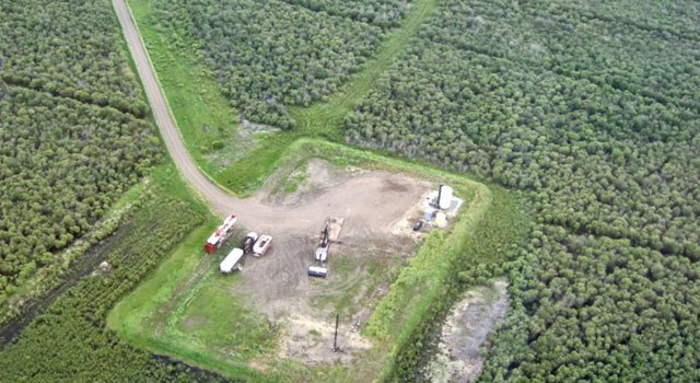
A typical Alberta oil well
The lack of ecological knowledge on the status of Alberta’s reclaimed industrial footprint is a potential liability that detracts from the Government of Alberta’s land stewardship commitments, and from industries’ social license to operate on public and private land. It’s also where the ERM project comes in. In 2012, AESRD contracted ABMI to work towards developing a long-term monitoring program for certified specified lands(3) in Alberta, starting with wellsites, and the ERM project was launched. The objective of this project is to develop a scientifically robust, transparent, and financially sustainable long-term reclamation monitoring system for reclaimed wellsites in Alberta.
During the winter of 2013 ABMI project scientists led workshops with professionals from industry and government to identify which indicators should be used to evaluate the ecological recovery of wellsites. Ecologists identified important indicators of vegetation recovery (e.g., per cent cover of individual plant species), and soil scientists identified important indicators of soil recovery (e.g., pH, bulk density). Using the identified recovery indicators, the ERM project developed a set of monitoring protocols that can be used to measure ecological recovery of soil and vegetation on certified wellsites in forested lands and grasslands of Alberta.

Field crew at work in the Dry Mixedgrass between Brooks and Taber in southern Alberta. Credit: Anne McIntosh
In summer 2013, with project collaborators at Alberta Innovates Technology Futures, field crews spent five weeks sampling soil and vegetation indicators at 18 wellsites and adjacent reference sites in the Dry Mixedgrass subregion of Alberta. From this effort, 1944 soil samples were collected and plant data was recorded from over 300 plots! In addition, lichen and moss samples were collected for future identification by ABMI taxonomists at the Royal Alberta Museum.
And, with this summer quickly approaching, ERM project scientists are busy planning the upcoming field season’s activities when the project moves to the boreal forest to test the monitoring protocols in that natural region and collect monitoring data, as well.
Funding for this project is currently provided by Alberta Environment and Sustainable Resource Development and the Alberta Upstream Petroleum Research Fund.
Upcoming Events
ERM project scientist Dr. Anne McIntosh is presenting “Evaluating the Past to Inform the Future: Monitoring Ecological Recovery of Soil and Vegetation Parameters on Reclaimed Wellsites” with Bonnie Drozdowski on Thursday, Feb 27th, as part of the Canadian Land Reclamation Association AGM. http://www.clra.ca/
Stay tuned for notification of publication of project results on the ecological recovery of certified wellsites in the Dry Mixedgrass subregion.
(1) Upstream oil and gas refers to the point where raw product is being collected, including wells, pipelines, satellites and batteries. (http://environment.alberta.ca/02484.html)
(2) The ability of the land to support various land uses after conservation and reclamation is similar to the ability that existed prior to an activity being conducted on the land, but that the individual land uses will not necessarily be identical.
(3) Specified lands include those used for industrial development that includes coal operations; mine, pit, borrow, excavation, quarry or peat operation; oil sands/oil sand exploration; railway; roadways; sand and gravel; telecommunications operations; transmission lines; upstream oil and gas