Wetlands provide numerous benefits to society, including clean and abundant water, flood mitigation, and habitat for wildlife. These benefits have become increasingly apparent, as wetlands are lost across Alberta resulting in greater risk to our infrastructure and biodiversity. Starting with agricultural settlement in southern Alberta, it’s estimated that approximately 64% of wetlands have been permanently lost. Each year, 0.3-0.5% of Alberta’s wetlands continue to be lost.
In 1993, the Government of Alberta introduced one of Canada’s first wetland policies. This policy was recently replaced by the Alberta Wetland Policy (September, 2013). The goal of this policy is “to conserve, restore, protect, and manage Alberta’s wetlands to sustain the benefits they provide to the environment, society, and economy. ” Not all wetlands are created equal, however; they differ in function and vary in abundance and provision of benefits. As a result, the policy employs the concept of “relative wetland value” to guide any management activities to be carried out under the policy. For example, “wetlands of the highest value” are identified as targets for long-term protection.
The policy also establishes the criteria for determining the “relative value” of a wetland: biodiversity, water quality improvement, flood reduction, human value, and current abundance. An assessment translates into each wetland receiving a score from highest [A] to lowest [D]. This score will be used to determine how best to avoid and/or minimize negative impacts to the wetlands.
The Alberta Wetland Policy requires credible and transparent science to support its implementation. Since 2007, the ABMI has run a province-wide wetland monitoring program examining how human footprint influences wetland number and quality. This positions the ABMI to report on two of the criteria to be used to assess wetlands: biodiversity and water quality improvement..
As of 2014, the ABMI has collected field data on 1,005 wetlands across the province. This represents the most significant investment in wetland monitoring in the province’s history. Every year we continue to monitor and re-assess these wetlands to determine the status and trends in water quality and biodiversity.
How Does the ABMI Monitor Wetlands?
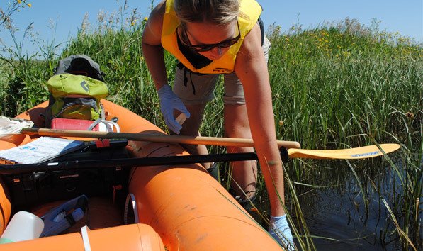
As per the Alberta Wetland Classification System, the ABMI surveys the wetland class designated as permanent “shallow open water”. Wetlands are selected with a surface area ranging from 1 and 100 ha, a maximum depth between 0.5 and 2 m, and that contain stable water levels year-round even in drought. Each wetland survey includes a physical description, including characterizations of the wetland’s zones, the area of the open water zone, its bathymetry, and the percent area covered by human footprint, broken down by category [1]. Various physiochemistry parameters are also measured: temperature, pH, dissolved oxygen, conductivity, salinity, total nitrogen and phosphorus, and dissolved organic carbon.
To determine the species that inhabit a given wetland, each wetland zone (from wetland margin zone to the open water zone) is surveyed to determine which vascular plants species are present. If unknown or uncertain species are encountered, voucher specimens are collected for later identification. To sample aquatic invertebrate diversity, dip nets are used throughout the open water zone of the wetland to collect specimens for later identification by ABMI taxonomists. In addition to data and specimens collected in the field, ABMI’s remote sensing specialists assess the amount and type of human-footprint surrounding each wetland visited.
Whether it’s to support the nascent Alberta Wetland Policy or other wetland-related land use planning processes, the ABMI has an extensive database to draw from and is publicly available at abmi.ca. Initial conclusions drawn from an analysis of the landscape- and/or local-level factors driving wetland nutrient variation in Alberta’s prairie wetlands, suggest water depth, surrounding agriculture footprint, and amount of precipitation received all significantly influence the water quality of these wetlands [ABMI Science Letter: Factors Affecting Nutrient Variation in Alberta Prairie Wetlands]. The ABMI’s wetland ecologist Dr. MC Roy is currently analyzing the effects of adjacent land-uses on the aquatic plants and invertebrate of Alberta, and will publish a follow-up Science Letter once the analysis is complete.