February 11 is the International Day of Women and Girls in Science. To celebrate, all February, we’ll be sharing the stories of some of the many women+ at the ABMI who have shaped our organization with their experience, expertise, and dedication. We are inspired by their hard work and the legacy that they are leaving for future scientists. Here is the first in a series of profiles of our prolific women scientists.
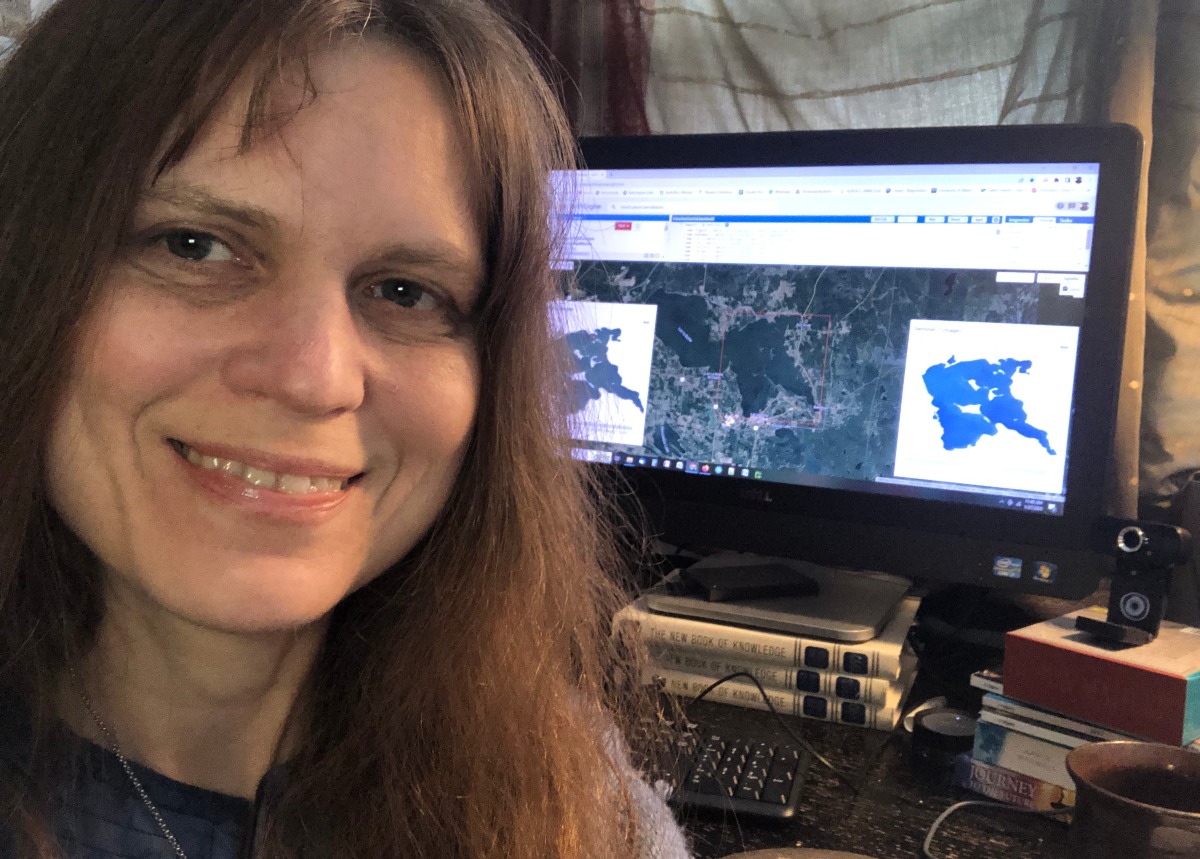
Fiona Gregory, Geospatial Analyst
From Canada’s high arctic to Alberta’s wetlands, forests and natural disaster sites, Fiona Gregory works with visually striking remotely sensed imagery to produce landcover maps and scientifically important data that are indispensable for the public, a wide range of stakeholders, and future scientists.
The Path to Geographic Information Systems
As a young girl, you could often find Fiona reading wildlife magazines and going on nature hikes in her native Athabasca, Alberta. Taking care of the environment and being in nature have always been among her top values and even though her high school didn’t offer a geography class, the seeds of bringing ecology, biology and mapping together had already been planted. Fiona remembers being proud of her initiative to create a huge hand-drawn map for her Mythology Unit in Language Arts.
While Fiona studied for her Bachelor’s in Geography at the University of Lethbridge, Geographic Informations Systems (GIS) was still an emerging field. She decided to pursue a certificate in GIS because it combined her interests of both physical and social sciences. Despite being intimidated by the technical and computational aspects of GIS, Fiona persevered thanks to encouragement by her professors and peers. After working as a consultant and then as a GIS teacher at a technical college, Fiona decided to pursue a graduate degree in geography specializing in earth observation and remote sensing. “One of the things that drew me to remote sensing is the fact that the satellite images are so beautiful,” Fiona says with a smile.
Fiona notes that she didn’t really feel like she was doing science until her Master’s Degree. “Before that, I felt more like a technician, but during my graduate work I had the opportunity to do field work, gather my own data and do the analysis. That is when I felt I was really doing science. It gave me such a different perspective.”
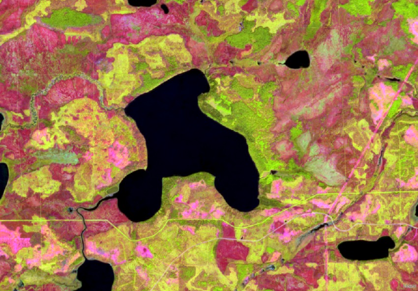
Satellite image of Northern Alberta (red is the burned area, and green shows regeneration.)
Mapping Canada’s High Arctic and High River
Fiona’s master’s thesis project was on mapping carbon dioxide exchange in vegetation in Canada’s high arctic. Her research took her to the remote Melville Island and she was part of the global initiative that is the International Polar Year1. Fiona was thrilled to personally do data collection and focus on her interests of remote sensing, vegetation and ecology. This unique experience allowed Fiona to live in a research camp with other researchers and spend long, windy days hiking the tundra in the middle of an arctic summer (with no setting sun). Fiona focused on ecological sampling of soils, plants and biomass as well as measuring carbon dioxide exchange in this geographically compelling area.
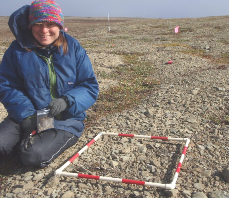
Biomass collection in the polar desert on Melville Island.
Another career highlight for Fiona was applying her mapping skills as the geospatial support person for the remediation effort following the devastating floods in High River in 2013. Each day Fiona would update and print maps of the status of properties requiring remediation for the workers to take with them. Her work included providing analysis with satellite images of the flood extent.
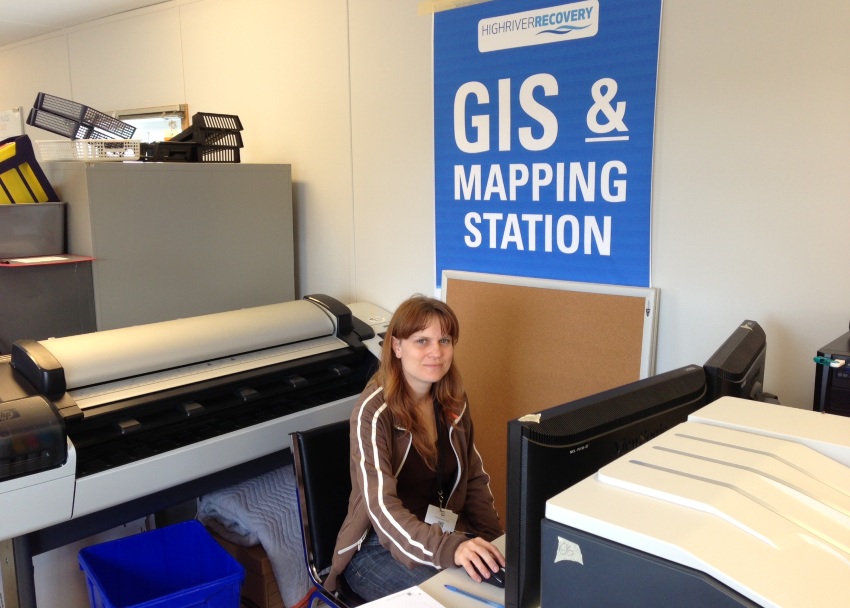
Fiona provided support for High River flood remediation in 2013.
Mapping Alberta’s Wetlands at the ABMI
As a geospatial analyst at the ABMI, Fiona’s work involves landcover mapping using satellite imagery to study a wide range of topics including wetlands, forest types and algal blooms in lakes. Using open source satellite imagery through Google Earth Engine, Fiona is able to map these over very large areas (such as over the entire province of Alberta). Fiona and her colleagues apply algorithms to the imagery, developing predictive models to create detailed mapping products. This involves a rigorous process of trial and adjustment to ensure that what the models predict aligns with reality: “Ground truth”, for example known locations of landcover types based on aerial photo interpretation or cyanobacteria pigments based on lake samples, is fed into the models to train them to map similar phenomena over the entire area of interest.
As with all ABMI data, Fiona’s work is freely available to the public, to stakeholders, to industry or other scientists on the ABMI website. This data can be used for habitat modeling or for any application that somebody might need a landcover map for.
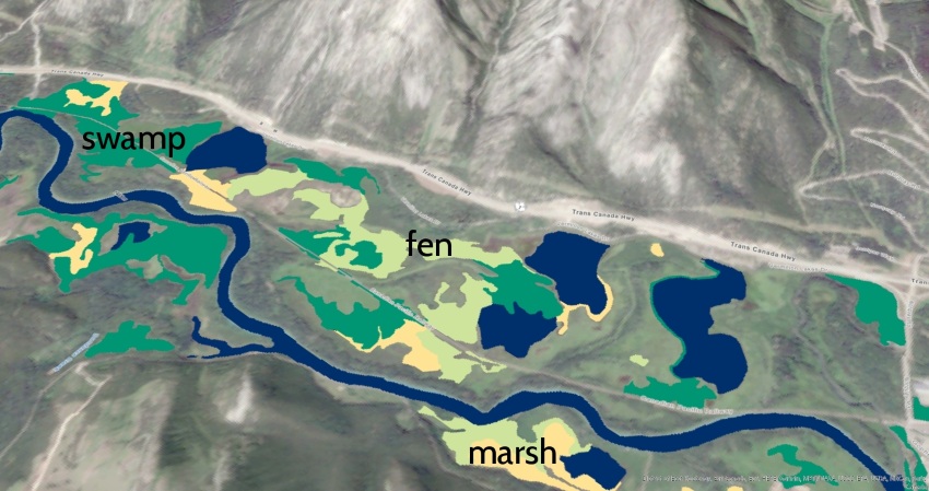
Mapping of Vermillion lakes in Alberta’s rocky mountains.
Since coming to the ABMI, Fiona is particularly proud of the wetland mapping and data that she has developed along with the geospatial team. Fiona contributed to an Alberta-wide wetland map, with her part focusing on Alberta’s rocky mountains. Fiona says that working at the ABMI has been a paradigm shift for her because using cloud computing and Google Earth Engine has allowed her to map larger areas, at greater temporal frequencies than ever before.
Currently, Fiona is investigating algal blooms on Alberta’s lakes. Algal blooms are of high interest to jurisdictions and the public as they can have a devastating impact on local biodiversity.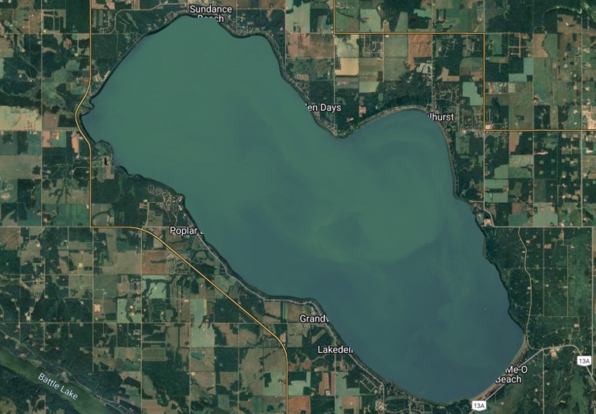
Geospatial Science & Women
It turns out that geospatial science is becoming a more and more welcoming place for women+:
There are a growing number of female geospatial and remote sensing scientists (ABMI’s Geospatial Centre happens to employ over 60% employees who identify as female), as well as increasing support for women+ in the geospatial fields. For example, Women in Geospatial, a global network of women+ in geospatial science, has expanded from just 300 members in 2019 to now more than 4,100 members. They state that “Our activities aim to inspire, unite and empower women+ in the geospatial field to become strong leaders and changemakers.” They have a newsletter, a slack channel, speakers database and also offer mentorships and meetups.
The Ladies of Landsat (Landsat is a satellite) boast over 5,000 followers (January 2023) and offer support and resources to women+ working in earth observation. They also organize conferences and meetups as well as promoting different women researchers in the field.
Fiona recommends that young girls and women pursue careers in geospatial science since it is such a rapidly developing and exciting field. “They’ll be starting out probably way ahead of where I was, and I’d say this is a good field for women to be in, there are lots of women in it, so don’t worry about that.”
While Fiona hasn’t faced discrimination as a woman in science, she says the film Picture a Scientist (2020) made a big impression on her. “I encourage everyone to watch that film so we can be alert to situations where someone is being bullied or treated unfairly because of their gender or any other reason, and speak up and support that person.”
Fiona also highlights that there are certain skills that are essential for success in science that are not taught formally, so it is important to have mentors or colleagues that support learning these skills.This could apply to anyone, but might apply especially to girls and women+. “Being detail-oriented and caring about the data you collect is key to success”, says Fiona, “because everything depends on the data”. Fiona also acknowledges the importance of collaboration and legacy, as she personally experienced support from a fellow researcher while she was mapping in Canada’s high arctic: “That really shows the importance of passing on the knowledge that you have to the next cohort and how much we owe the ones who have come before us.”
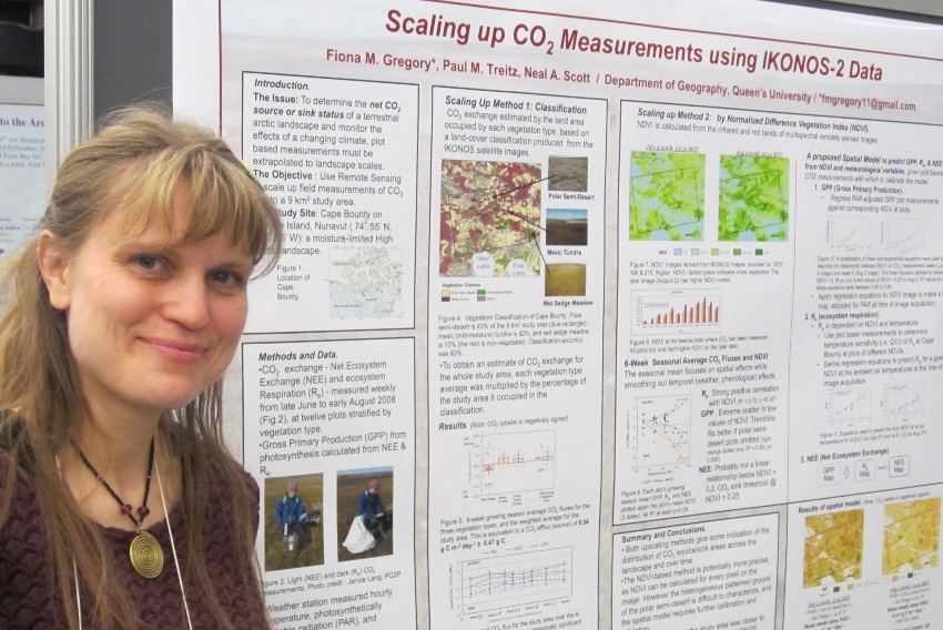
Poster of Fiona’s graduate work on CO2 measurements in Canada’s High Arctic during the International Polar Year.
As the field of GIS continues to evolve, so does Fiona’s work. “I’ve always identified as a geospatial analyst, later as a remote sensing specialist and image analyst but now apparently I’m a data analyst. I could even call myself a data scientist because the fields of data science and remote sensing are converging.” Fiona is looking forward to being a part of these rapidly-changing developments in data science, computer-based data and machine-learning. She notes that there’s probably more work for GIS specialists than ever before, because there are infinitely more possibilities.
For more information and links to Geospatial resources:
- Fiona Gregory ResearchGate Profile
- Geospatial work at ABMI
- Women in Geospatial
- Ladies of Landsat
- Picture a Scientist (2020), available on Netflix.
- The International Polar Year (IPY) are collaborative, international efforts with intensive research focus on the polar regions. The 4th International Polar Year (2007-2008) comprised an intense, coordinated field campaign of observations, research, and analysis. It was the largest, most comprehensive campaign ever mounted to explore the Earth’s polar regions. An estimated 50,000 researchers, local observers, educators, students and support personnel from more than 60 countries were involved in the 228 international IPY projects (170 in scientific research, one in data management, and 57 in education and outreach[8]) and related national efforts. Source: Wikipedia