All posts in Remote Sensing

ABMI Presents State-of-the-Art Remote Sensing Visualization Product at MultiTemp 2013

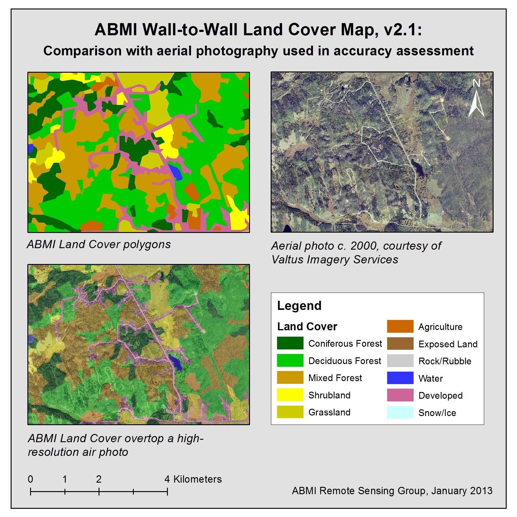
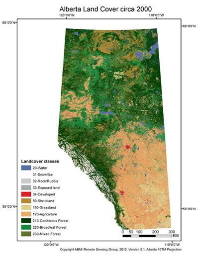
Due to human activity, the global environment is undergoing significant and rapid change. To assess the scope and impact of these changes, the science of remote sensing[1] is constantly evolving and delivering more powerful tools to observe the Earth’s surface.  Over the past decade, large, freely-available remote sensing data sets have also become available. The [...]

MultiTemp 2013: ABMI Prepares for the Canadian Debut of Innovative Remote Sensing Conference

Monitoring change in the Earth’s surface over local, regional, and global scales in a comprehensive, synoptic manner regularly relies on remote-sensing imagery collected from platforms such as airplanes or satellites. The growing archive of currently-accessible satellite imagery, which now covers over four decades, continues to support the increasing need for more accurate and integrated information on [...]

Figure showing ABMI Land Cover versus high-resolution photography.

Masters Project Enables Efficient Assessment of ABMI Land Cover Product’s Accuracy

Accuracy assessment is an important step in the production of any remote sensing-based map, and was a major component in the production of the ABMI Remote Sensing Group’s Wall-to-Wall Alberta Land Cover Map version 2.1 (circa 2000).  Assessing the accuracy of a province-wide map is no small task, particularly when the map is not a [...]

Greg McDermid receiving his award

Remote Sensing Group’s Greg McDermid Honoured with Distinguished Academic Early Career Award!

This September, our very own Dr. Greg McDermid of the ABMI Remote Sensing Group was honoured with the 2012 CAFA (Confederation of Alberta Faculty Associations) Distinguished Academic Early Career Award at an awards ceremony in Edmonton. The award recognizes those academic staff members who have made outstanding contributions to the wider community while in the [...]

A map of native vs. non-native grassland types at CFB Suffield

Student Project Reveals the Power of Remote Sensing in Identifying Native vs. Non-Native Grasslands

Will McInnes is a recent graduate of the University of Calgary’s Masters in Geographic Information Systems (MGIS) program in the Department of Geography, and author of an ABMI-funded MGIS thesis project that successfully tested a multi-temporal remotely-sensed data set in the mapping of native vs. non-native grasslands over several different Albertan prairie subregions.  An expansion [...]

Mud, Mosquitos, and More Mud: The Remote Sensing Group’s 2012 Field Season

Though somewhat bittersweet, our crews are very excited to report a successful end to the 2012 field campaign.  Our team lead, Sande Dalton, reminisces fondly about the sunny days hiking through Alberta’s northern boreal forest and nights of camping at beautiful Christina Lake. Other crew members included Chun Hua Zhang, Riley Iwamoto, and Lauren Peters.  [...]

Remote Sensing Group Completes New Wall-to-Wall Land Cover Map

After months of hard work, the ABMI Remote Sensing Group is very pleased to announce the completion and release of the ABMI Wall-to-wall Land Cover Map version 2.1!  A long-awaited data product, the spatially exhaustive polygon vector layer represents land cover across Alberta circa 2000, uses 11 land cover classes, and contains roughly one million, [...]

Newest Member in the Family – the senseFly swinglet CAM Unmanned Areal Vehicle (UAV)

While remote sensing is presently an activity that we think of as taking place primarily on large aircraft or spacecraft, recent happenings in The Foothills Facility for Remote Sensing and GIScience (F^3GISci; home of the ABMI Remote Sensing Group) offers a glimpse into the discipline’s future.